| |
| Greathouse Point > Greathouse Archives > USA > WV > Monongalia County | ||||
Greathouse of Monongalia County, WV
Do you have any Greathouse kith and kin who resided in Monongalia County, WV? If so, please join us in our efforts to better document the Greathouse kith and kin who lived in this county, by sending your additions and corrections to Greathouse Point.
1782, Jun 24 - Land Entry/Survey/Grant: John P. Duval, 640 Acres, Letart
1782, Jun 24 - Land Entry: John P. Duval, 640 Acres, Letart The claim appears to have been entered by Daniel McFarland who transferred his rights to John P. Duval. This land entry has not been found among extant claims to unpatented lands available on the microfilm.
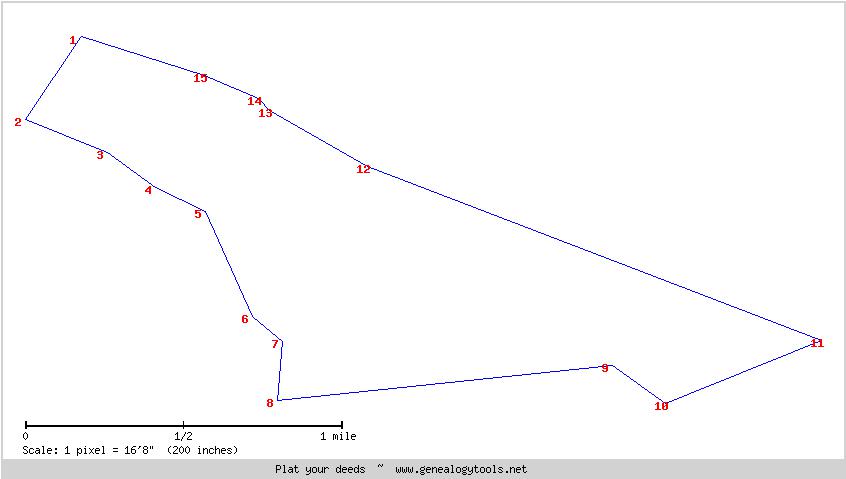
1782, Oct - Survey: John P. Duval, 640 Acres, Letart
Survey'd for John P. Duval Ass'ee of Danl. Mcfarland 640 Acres of Land in Monongalia County on part of preemption Warr't of 1000 Acres No. 2165 dat'd the ..th of Oct'r 1782 Ent'd the 12th of Feb'y 1783 on the Ohio River opposite the upper of the first Island above Letarts falls Adjoining Lands of Joseph Tomlinson Bounded as followeth (Viz); Beginning at a beach and Lynn corner to said Tomlinson S 34 W 100 ps. to a sug'r tree & Hickory S 86 E 90 ps. to a white oak & ash S 54 E 60 ps. to a white oak and Chestnut oak S 65 E 56 ps. to a black Gum & white oaks N 86 E 170 ps. to a pine & Dogwood S 69 W 491 ps. to two Maples .... River and down the river with its Meanders ... W 114 ps. N 45 W 16 ps. N 67 W 60 N 71 W 110 ps. to the Beginning Saml. Hanway S. M. C. Footnotes:
1784, Dec 10 - Land Grant: John P. Duvall, 480 Acres, Letart John P. Duvall, 480 Acres, Monongalia, Examined
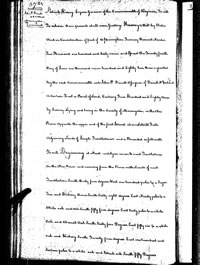
Patrick Henry Esquire Governor of the Commonwealth of Virginia To all To whom these presents shall come, Greeting: Know ye, that by Virtue and in Consideration of part of a preemption Treasury Warrant Number Two Thousand one hundred and Sixty seven and Issued the Twenty fourth Day of June one thousand seven hundred and Eighty two, there is granted By the said Commonwealth unto John P. Duvall Assignee of Daniel McFarland a Certain Tract or Parcel of Land, Containing Four Hundred and Eighty Acres by Survey Lying and being in the County of Monongalia, on the Ohio River Opposite the upper end of the first Island above Letarts Falls adjoining Lands of Joseph Tumblestone's and is Bounded as followeth To wit, Beginning at a Beach and Lynn corner to said Tumblestones on the Ohio River and running from the River with Lands of said Tumblestone South thirty four degrees West one hundred poles to a Sugar Tree and Hickory S 34 degrees W 100 poles thence South Sixty eight degrees East Ninety poles to a White oak and Ash S 68 degrees E 90 poles South fifty four degrees East Sixty poles to a white Oak and Chestnut Oak S 54 degrees E 60 poles South Sixty five Degrees East fifty six to a white Oak and Hickory S 65 degrees E 56 poles South Twenty four degrees East one hundred and Sixteen pole to a white oakd and Black oak S 24 degrees E 116 poles south fifty degrees East forty poles to two Hickorys S 50 degrees W 40 poles South five Degrees West Sixty pole to a black Gum and white oak S 5 degree W 60 poles North Eighty four Degrees East three hundred and forty poles to two Hickorys N 84 degrees E 340 poles South fifty four degrees East Sixty six poles to two white Oaks S 54 degrees E 66 poles North Sixty eight degrees East one hundred and Seventy Poles by Lands of said Duvalls to a pine and Dogwood N 68 degrees E 170 poles thence South Sixty nine Degrees West four hundred and ninety one poles to Two maples on the Ohio Bank and down the River with its Meaders S 69 degrees W 491 poles South Sixty Degrees West one hundred and fourtee poles S 60 W 140 poles North forty five Degrees West Sixteen poles N 45 degrees W 16 poles North Sixty seven degrees West Sixty poles N 67 degrees W 60 poles North Seventy One degrees West one hundred and ten poles to the Beginning with its meanders N 71 degrees W 110 [90] poles to have to hold the said Tract or parcel of Land With its Appurtenances, to the said John P. Duvall and his Heirs for ever. In Witness Whereof, the said Patrick Henry Esquire Governor of the Commonwealth of Virginia, hath hereunto set his Hand, and Caused the Lesser seal of the said Commonwealth to be affixed at Richmond, on the Tend day of December in the year of Our Lord, one thousand seven hundred and Eighty four and of the Commonwealth the Ninth. Patrick Henry
Excerpt from Metes and Bounds Prepared and Revised for Use with Deed Platter: Beginning at a Beach and Lynn corner to said Tumblestones on the Ohio River and running from the River with Lands of said Tumblestone South thirty four degrees West one hundred poles to a Sugar Tree and Hickory S 34 degrees W 100 poles 100 poles x 16.5 feet = 1,650 feet thence South Sixty eight degrees East Ninety poles to a White oak and Ash S 68 degrees E 90 poles 90 poles x 16.5 feet = 1,485 feet South fifty four degrees East Sixty poles to a white Oak and Chestnut Oak S 54 degrees E 60 poles 60 poles x 16.5 feet = 990 feet South Sixty five Degrees East fifty six to a white Oak and Hickory S 65 degrees E 56 poles 56 poles x 16.5 feet = 924 feet South Twenty four degrees East one hundred and Sixteen pole to a white oakd and Black oak S 24 degrees E 116 poles 116 poles x 16.5 feet = 1,914 feet south fifty degrees East forty poles to two Hickorys S 50 degrees W 40 poles 40 poles x 16.5 feet = 660 feet South five Degrees West Sixty pole to a black Gum and white oak S 5 degree W 60 poles 60 poles x 16.5 feet = 990 feet North Eighty four Degrees East three hundred and forty poles to two Hickorys N 84 degrees E 340 poles 340 Poles x 16.5 feet = 5,610 feet = 2 x 2,805 feet South fifty four degrees East Sixty six poles to two white Oaks S 54 degrees E 66 poles 66 poles x 16.5 feet = 1,089 feet North Sixty eight degrees East one hundred and Seventy Poles by Lands of said Duvalls to a pine and Dogwood N 68 degrees E 170 poles 170 poles x 16.5 feet = 2,805 feet thence South Sixty nine Degrees West four hundred and ninety one poles to Two maples on the Ohio Bank and down the River with its Meaders S 69 degrees W 491 poles 491 poles x 16.5 feet = 8101.5 feet = 2 x 4050.75 feet South Sixty Degrees West one hundred and fourtee poles S 60 W 140 poles 140 poles x 16.5 feet = 2,310 feet North forty five Degrees West Sixteen poles N 45 degrees W 16 poles 16 poles x 16.5 feet = 264 feet North Sixty seven degrees West Sixty poles N 67 degrees W 60 poles North Seventy One degrees West one hundred and ten poles to the Beginning with its meanders N 71 degrees W 110 [90] poles 110 poles x 16.5 feet = 1,815
Sources: Monongalia County, WV, Claims to Unpatented Lands, Microfilm, Page 370, 1782 - Land Entry: John P. Duvall, assignee of Daniel McFarland not found. Monongalia County, WV, Survey Book 4, Page 512, 1782, Oct - Survey: John P. Duval, 480 Acres, Letart. View Survey @ Fold3 Greathouse Point, Greathouse Archives, USA - Mason County, WV. Mapping Big Mill Creek, 1780-1820: Early Landowners of Letart, Millwood and Evans, West Virginia Virginia, Land Office Grants No. 2, 1786, (Reel 68), microfilm. Page 372-373, 1784, Dec 10 - Land: John P. Duvall. Virginia State Land Office. Grants A-Z, 1-124, reels 42-190; Virginia State Land Office. Grants 125- , reels 369-. Land Office Grants N, 1784-1785, p. 372 (Reel 54). Page 372-373, 1784, Dec 10 - Land: John P. Duvall, 480 Acres, Letart. View Grant @ Fold 3 [ Page 372 | Page 373 ] |
||||
Disclaimer All information submitted to this site remains to the extent the law allows, the property of the submitter who, by submitting it, agrees that it may be freely copied, but never sold or used in a commercial venture without the knowledge and permission of its rightful owner. |
||||
 |
 |
|
Copyright © 1998 - 2011, Greathouse Point. Terms of Use | Privacy Policy | Site Map |